
THIS is the full list of former Wirral car parks, hotels, train stations and estates that could soon be home to offices, shops and industry – and some of them are absolutely huge.
The list of sites recommended for consultation for new employment development and mixed uses has been revealed by the council as part of its core strategy local plan.
It's set to be discussed by the council's special meeting of the cabinet on Monday, and will be considered alongside almost 50 green belt sites and 91 brownfield sites which could be used for new homes.
Subject to an extensive public consultation, it's in a bid to meet huge government-imposed housing targets, and the news – particularly with regards to the green belt sites – has been met with outrage.
But the move will also include asking the public for their views on this list of even more brownfield sites that could soon see commercial mixed use blocks, offices and potentially even more homes being built.
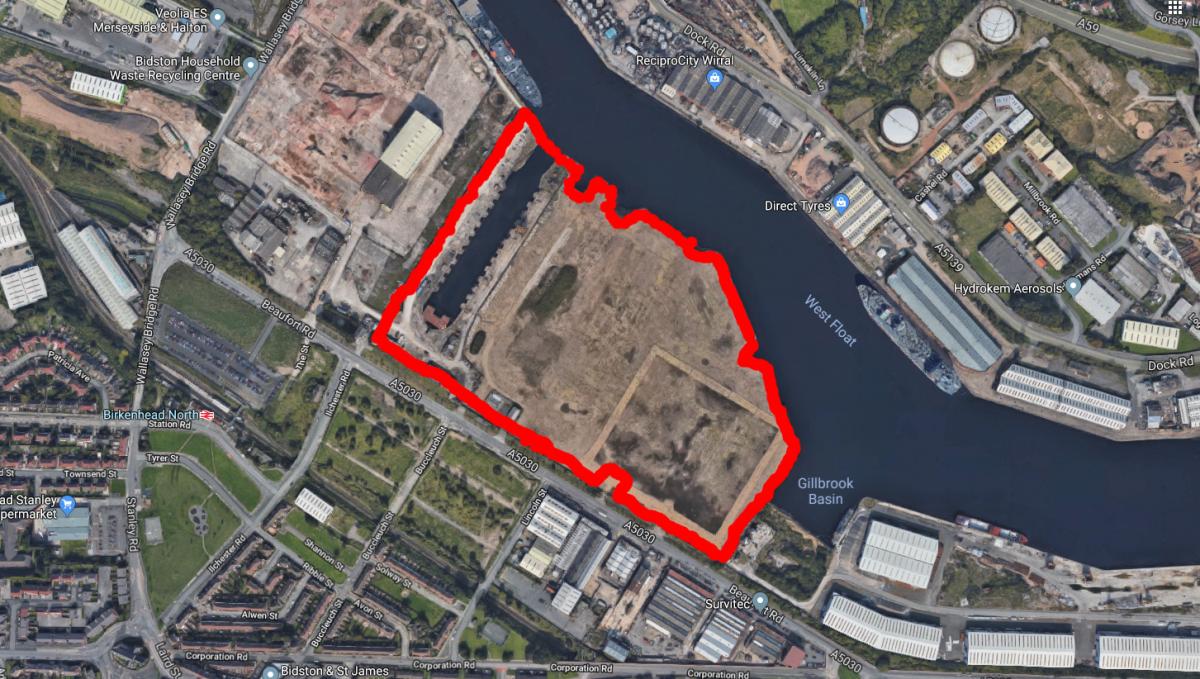
Some of them are vast in size, with the largest – the former food producer RHM Mills' site in Birkenhead docks – the size of 14 rugby pitches.
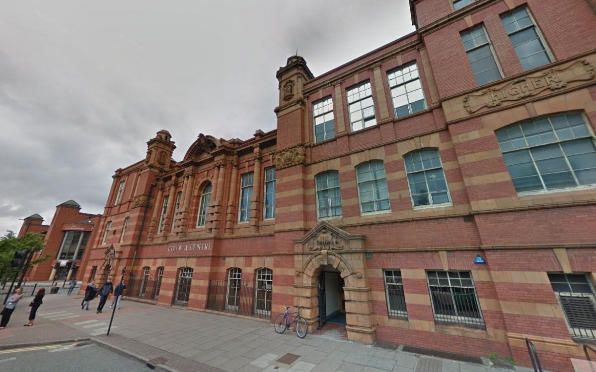
Others include the former Royal Swan Hotel on Dock Road in Seacombe, the old Town Station in Birkenhead, which closed down at the end of the Second World War and the Conway Centre.
The list also includes the sites set for Wirral Waters – the huge development which has been the cause of some controversy in recent days.
Councillor George Davies, cabinet member for housing and planning, said: "We will meet our statutory obligations, we will develop a Local Plan which meets residents' needs, but we must and will do everything we can to protect the special character of Wirral.
"This consultation is vital, and I hope every Wirral resident is able to get involved and make their voice heard."
These are the sites recommended for potential allocation for new employment development – for business, general industry and storage and distribution.
They are listed ward-by-ward, with their size in hectares:
Bidston and St James
- Birkenhead Dock Estate – Bidston Dock – 10.4ha
- Birkenhead Dock Estate –former RHM MIlls – 14.17ha
- Former Mobil Oil, Wallasey Bridge Road – 9.33ha
- Former Training Ground, Valley Road – 1.15ha
- Former Warehouse, Cleveland Street – 0.98ha
- Ten Streets - Phase 1, Berner Street, Birkenhead – 0.98ha
- Ten Streets – Phase 4, Lynas Street, Birkenhead – 0.33ha
Birkenhead and Tranmere
- Twelve Quays – Morpeth Waterfront – 1.36ha
- Twelve Quays, Tower Wharf – 1.01ha
Bromborough
- East of Tulip, Riverview Road – 1.91ha
- Former Builders Yard, Magazine Lane – 1.01ha
- Former Croda, Prices Way – 4.41ha
- Former Eastham Sand, Riverbank Road – 1.94ha
- Former Epichem, Power Road (subject to Tree Preservation Order) – 1.93ha
- Former MOD, Old Hall Road – 6.85ha
- Former RV Chemicals, Riverbank Road – 8.05ha
- Former Spectrum, Caldbeck Road – 2.36ha
- Former Tank Farm, Commercial Road – 0.97ha
- North of Tulip, Plantation Road – 2.18ha
- Riverbank Road, Magazine Lane – 1.6ha
- Riverside Park (Phases 2b – 4), Southwood Road – 3.03ha
- Slack Wood, Riverview Road – 1.35ha
- Former Lubrizol, Dock Road South 10.47ha
- Southern Reclamation Area, Bromborough Coast – 9.63ha
Eastham
- Eastham Dock Estate – North Road Tank Farm – 8.38ha
- Eastham Dock Estate – Queen Elizabeth II Dock – 6.57ha
Leasowe and Moreton East
- Peninsula Business Park, Moreton – 1.13ha
- Premier Brands, Reeds Lane – North of Access Road – 1.46ha
Moreton West and Saughall Massie
Tarran IE – Tarran Way North – 0.24ha
Prenton
North Cheshire TE – Land at Prenton Way – 0.57ha
Seacombe
- Former Gas Holders, Dock Road – 2.32ha
- Former Pallet yard, Birkenhead Road – 0.63ha
- Former Royal Swan Hotel, Dock Road – 0.38ha
- North of Oakdale Road, Seacombe – 0.78ha
- SMM Business Park, Dock Road – 6.86ha
- West Float Industrial Estate, Dock Road – 0.34ha
- Wheatland Lane, Seacombe – 0.5ha
These sites are listed in the document for potential allocation for new mixed use development – of "primarily commercial character":
Bidston and St James
Wirral Waters – Tower Quay – 0.4ha
Prenton
Former Horticultural Training, North Cheshire TE – 0.47ha
Seacombe
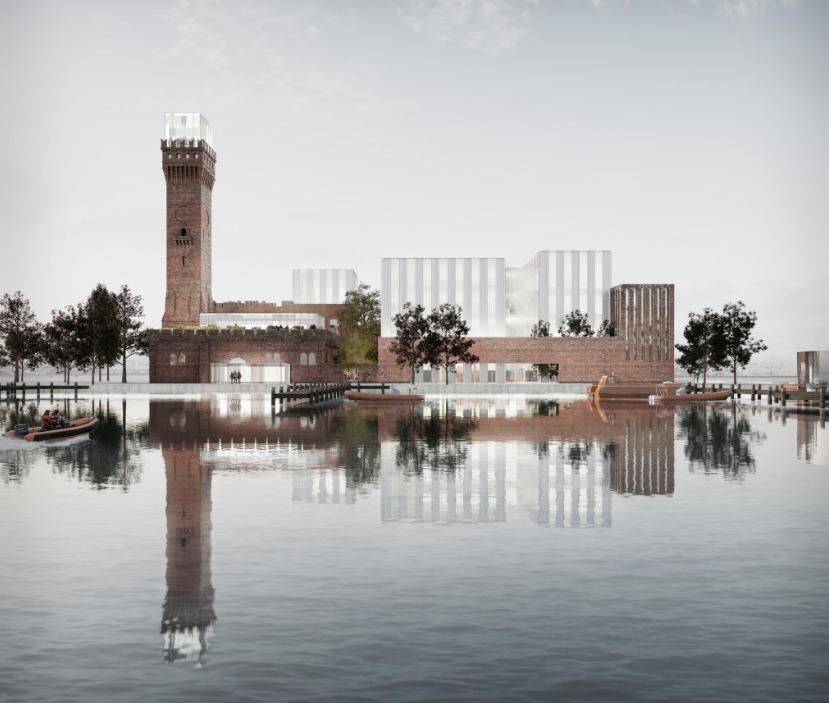
Wirral Waters – Hydraulic Tower – 0.83ha
And these are the sites recommended for consultation for the allocation of “mixed use” developments, which can also include housing:
Bebington
Land at Civic Way, Bebington – 0.84ha
Bidston and St James
- Land at Beaufort Road, Birkenhead – 3.57ha
- Wirral Waters – Sky City – 5.39ha
- Wirral Waters – Vittoria Studios – 6.34ha
- Wirral Waters – Marina View – 4.8ha
Birkenhead and Tranmere
- Former Mollington Street Depot – 4.05ha
- Conway Park – North of Station – 1.24ha
- Former Gas Depot, Hind Street – 3.84ha
- Former Town Station, Borough Road East – 1.26ha
- Rose Brae, Church Street – 1.96ha
- Conway Park – Cinema Frontage – 0.1ha
- Conway Park – NE of Crown Hotel – 0.16ha
- Former Rank Bingo, Conway Street – 0.24ha
- West of Town Station, Jackson Street – 0.34ha
- Woodside Regeneration Area – 9.33ha
- Land at Oxton Road, Birkenhead – 0.36ha
- AEV, Marion Street, Birkenhead – 0.33ha
- West of 22 Lorn Street, Birkenhead – 0.17ha
- Duncan Street Car Park, Birkenhead – 0.09ha
- Conway Building, Birkenhead – 0.23ha
- Treasury Building, Cleveland Street – 0.44ha
- Elgin Way Car Park, Birkenhead – 0.11ha
- Hinson Street Car Park – 0.22ha
Bromborough
- Bromborough Civic Centre, Allport Lane – 0.43ha
- Allport Lane Car Park, Bromborough – 0.43ha
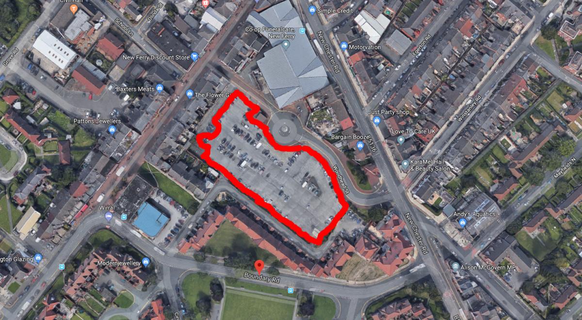
- Woodhead Street Car Park, New Ferry – 0.43ha
Clatterbridge
Vacant land at Clatterbridge Hospital – 3.08ha
Hoylake and Meols
Former Town Hall and Grosvenor House, Albert Road, Hoylake – 0.16ha
Leasowe and Moreton
- East East of Typhoo Tea, Reeds Lane – 5ha
- Land North of Moreton District Centre – 2.66ha
Liscard
Former Municipal Offices, Egerton Grove, Liscard – 0.49ha
New Brighton
Former Grand Hotel, Marine Promenade – 0.15ha
Seacombe
Wirral Waters – North Bank East /Tower Road – 0.56ha
Upton
North of 41 Eltham Green, Woodchurch – 0.12ha
Wallasey 215 Wallasey Village – 0.1ha
The full list, including maps of all sites, can be found on the meeting's agenda page here: https://democracy.wirral.gov.uk/mgAi.aspx?ID=44834#mgDocuments


Comments: Our rules
We want our comments to be a lively and valuable part of our community - a place where readers can debate and engage with the most important local issues. The ability to comment on our stories is a privilege, not a right, however, and that privilege may be withdrawn if it is abused or misused.
Please report any comments that break our rules.
Read the rules hereLast Updated:
Report this comment Cancel